Space Products & Innovation
Energy, Resources, and Environmental Management
2020 TSRQ3 – Space Products & Innovation
The increased use of satellite imagery and data in recent years has led to expansions in multiple fields of research. The utilization of satellites has developed beyond just tracking weather patterns. Satellites are now used to study . . .
2019 TSRQ1 – Space Products & Innovation

Companies and individuals are using positioning, navigation and timing (PNT), Earth observation (EO), and communication satellite technologies and data to humanity’s benefit. From commercial transportation to natural disaster relief, these products and services are changing, for the better, the way humans . . .
2016 – Herding Cattle from Space
Ranchers and space technology work together to herd cattle.
Energy, Resources, and Environmental Management
Due to the wide perspective of Earth provided by some satellites, industries involved in energy, resources, and environmental management are benefiting from multiple new developments in satellite technology and services. The Earth’s environment is in constant flux as natural resources are consumed and renewed continually.
Products and Services: Space Products and Services – TSR 2015
Understanding Droughts and Floods through GRACE
Water—either too much or not enough of it—can pose very different challenges to residents of certain regions in the world. There are satellites that measure the amount of water within the soil of the region and give a better idea if the observed ground is prime for flooding or drought.
Satellites Help Find Treasured Trash
Satellite imagery continues to be used in surprising ways. One startup, Terra Recovery, is using satellite remote sensing technology in tandem with flying drones to find mining opportunities in the United Kingdom and North America.
European Radar Satellite Helps with California Quake
The August 2014 earthquake in Napa Valley, California prompted organizations from very different backgrounds to provide space-sourced data to the affected communities. The European Space Agency (ESA), the United States Geological Survey (USGS), and Google all provided information showing the aftermath of the 6.0 magnitude earthquake.
Space Products and Services – TSR 2014
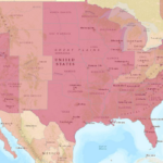
Measuring Pollution with Aqua
NASA measures atmospheric nitrogen dioxide concentration using a sensor on the Aqua satellite, indicating the severity of air pollution. Applying these satellite measurements of air pollution to maps showing total population of urban areas, NASA scientists have identified a series of regional relationships between pollution and population.