Germany
2013 – PISA

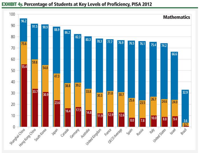
Trends in international primary and secondary STEM education can be compared across countries using two widely respected international exams. The Programme for International Student Assessment (PISA), carried out by the Organisation for Economic Co-operation and Development (OECD) every three years, focuses on the capabilities of 15-year-old students in mathematics and science literacy.
2013 – European Space Industry Employment
Space employment in Europe has increased for the seventh year in a row, adding about ## employees from 2011 to 2012, an increase of ##%. European space employment is ##% greater than its 10-year low in 2005. Unlike the data for the U.S. space workforce, which is estimated using nationally collected data not specifically designed to capture the space industry, data on the European space workforce has been collected via a targeted survey of European space companies carried out by a not-for-profit organization, Eurospace. In carrying out this survey, Eurospace focuses on manufacturing activities and measuring end-market value.
PNT Data For Finding the Smallest of Tasks
Companies can capitalize on smartphones with GNSS receivers in new ways to reduce their operating costs. Microjobbing, or crowdsourcing small jobs rather than dispatching employees to perform a simple task, is the aim of German startup company “wer denkt was” and its smartphone application AppJobber. Registered users of AppJobber can view nearby microjobs on a map and complete the requested task in exchange for a few euros transferred from the company into their AppJobber account.
Getting a Charge with mapZero
Beyond turn-by-turn navigation, GNSS abilities within smartphones are increasingly used to facilitate daily travel experiences. Owners of electric vehicles from cars to Segways are limited by the range of their vehicles, and that distance can vary substantially, depending on driving conditions.
2013 – Changing Context in Government Space Programs: National, Regional, and Local
As the commercial space sector matures, government space programs wrestle with defining the context and objectives for scientific and exploration activities while optimizing economic and societal return through space applications. International planning for space exploration activities provides a fr… Thank you for visiting The Space Report! The Authoritative Guide to Global Space Activity, Packed with…
Economy: Space Economy – TSR 2013
2012 – On-Orbit Servicing
Much of the world depends on GEO satellites for defense, communication, science, and weather monitoring. These expensive assets eventually fail or run out of propellant, but refueling and maintaining them can extend their lives, giving their users more value. Servicing can also help make space more sustainable because broken and drifting satellites take up valuable real estate in GEO and pose a risk to neighboring systems.
2012 – Land Imaging
Land imaging satellite performance is described using a variety of characteristics, including differences in spatial resolution (as measured by how many pixels compose an object), positional accuracies (as measured by the extent to which objects are represented accurately), and spectral capabilities (as measured by wavelengths of light captured, including visible and beyond-visible spectra). High-resolution land imaging satellites have resolutions below 1 meter (3 feet) per pixel, allowing users to distinguish cars from trucks, for example.
2012 – ESA: SSA
Europe is investing in a pan-European SSA capability through an ESA program that was initiated in 2009. Investment of €## million (US$## million) was initially requested for full-scale development, but ESA governments decided to spend only €## million (US$## million) over three years. So far, ESA has spent €## million (US$## million) on development. Some of that funding supported construction of ## prototype space surveillance radars. The first radar, located in Spain and built by Germany, was completed in October 2012 with validation and testing beginning in November.
2012 – Remote Sensing Ground Networks
Ground facilities support space infrastructure by controlling spacecraft or processing the data that satellites gather and send to Earth. Remote sensing satellites orbit the Earth, gathering data that then needs to be archived, processed, and analyzed while the satellites themselves need to be tasked and targeted to collect imagery in the most efficient manner possible. To perform these tasks, commercial remote sensing satellite operators have established networks of satellite control stations, data reception stations, and data processing centers.