France
2016 – Economy: Space Economy
The global space industry continued to grow in 2015, although currency fluctuations caused the appearance of a slight decline . . .
European Space Industry Workforce by Country 2000 – 2020
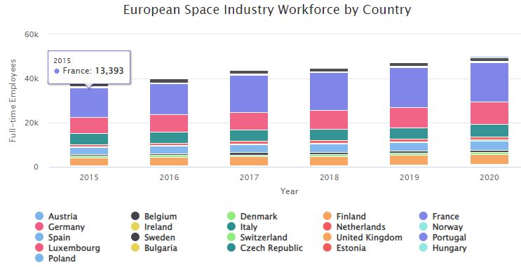
Stacked bar chart showing a twenty-year look at the European space industry workforce by country 2000 – 2020
2015 – France: SSA – Snapshot
SSA operations in France are shared by the French Air Force and the Centre National d’Études Spatiales (CNES). The missions for French SSA activities are similar to U.S. military efforts, attempting to catalog all low Earth orbiting objects for collision and launch avoidance. The French do use U.S. SSA-provided data, but they augment the data with data from their own systems.
2015 – European Space Industry Employment – Snapshot
Data on the European space workforce is collected annually via surveys by Eurospace, an association of the European space manufacturing industry. The survey focuses on design, development, and…
2015 – German Government Space Budget – Snapshot
Overall, Germany’s spending on space activities in 2015 totaled €1.425 billion (US$1.589 billion), an 8.0% increase from €1.319 billion (US$1.806 billion) in 2014. Germany’s contribution to…
2015 – French Government Space Budget – Snapshot
In 2015, Centre National d’Etudes Spatiales (CNES), France’s space agency, had a budget of €2.126 billion (US$2.371 billion). This was a 1.3% decrease from its 2014 budget of €2.153 billion…
2015 – Government Space Budgets – Snapshot
Total global government space budgets in 2015 were $76.516 billion, a 4.8% decrease from $80.415 billion in 2014. More than half of this spending was in the United States, which budgeted $44.567 billion for government space activities in 2015. Government budget levels reflect the most recent budgetary information available for each country, taking into account the fact…
Economy: Space Economy – TSR 2015
2014 – Military Communications
Global, dedicated, and secure communications networks are vital to governments, militaries, and agencies around the world. Increased demand for capacity—particularly secure connectivity using non-commercial frequency bands—continued to drive deployment of dedicated military communications satellite systems. The U.S. military bought significant capacity from commercial operators such as Intelsat and SES in 2014. However, the way the military buys the bandwidth has been criticized by commercial satellite communications services as expensive and outdated.
2014 – Meteorology
Weather satellites are a major segment of remote sensing satellites, using a mix of electro-optical, atmospheric, gravimetric, SAR, and other sensor payloads to detect fully formed weather systems as well as precursor conditions. Most weather satellites are in GEO or polar LEO orbits and have traditionally been operated by national governments for near-term weather forecasting and long-term climate modeling.